
by Michael Mathes
MANDEVILLE, United States (AFP) — Barry weakened further on Sunday as the storm churned across the US state of Louisiana, bringing along heavy rains and the possibility of flooding and tornadoes.
There have been no reported deaths so far in Louisiana or neighboring states from Barry, which had briefly become the first hurricane of the Atlantic season before the National Hurricane Center downgraded it to a tropical storm and then a tropical depression.
Still, as the storm moved inland on a northern track, it packed a serious punch.
Louisianans kept a wary eye on rivers and canals badly swollen by the torrential rainfall, following an extraordinarily wet season farther up the Mississippi River.
This is “the wettest year we’ve had since 1895,” Major General Richard Kaiser, who heads the Mississippi River Commission, said on Fox News.
He said the broad river is “the highest it’s been for a long time” — just below flood stage.
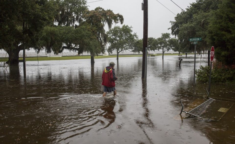
Bands of heavy rain continued to lash New Orleans, the state’s biggest city, but its airport was able to resume normal service after canceling all flights on Saturday.
Fears that the levee system protecting New Orleans could be compromised eased.
Mayor LaToya Cantrell, who a day earlier had urged residents not to be complacent, said in a news conference Sunday that “we absolutely made it through the storm. We are lucky; we were spared.”
Dangers remain
As of 4:00 pm Sunday (2100 GMT), the storm’s maximum sustained winds had dropped to 35 miles (55 kilometers) per hour. It was located north-northeast of Shreveport in western Louisiana, moving towards Arkansas, the National Hurricane Center said.
“Further weakening is expected as the center moves farther inland, and Barry is forecast to degenerate into a remnant low pressure system by Monday night,” the NHC said.
US Senator Bill Cassidy said of the storm on Fox News: “We have seen worse.”
Evacuation orders had already been lifted in several locales including Plaquemines Parish, south of New Orleans, where up to 10,000 residents had been under orders to leave.
But on Sunday, National Guard members were still laying down sand-filled barriers in a bid to contain flooding after “severely high water” overtopped levees in the Plaquemines town of Myrtle Grove, according to parish information officer Jade Duplessis.
Pete Gaynor, acting administrator of the Federal Emergency Management Agency, told Fox that “there are still life-threatening conditions.”
“The rain is the threat,” he added, noting that floodwaters farther up the engorged Mississippi will be moving south in coming days.
Many coastal areas remained on alert.
Tornadoes were possible in parts of Louisiana, Mississippi, Alabama, Arkansas and Tennessee, the NHC said.
Rainfall estimates lowered further to between three and five inches (8 to 13 centimeters) over south-central Louisiana but rivers and canals are already near capacity.
Across southern Louisiana, Barry’s heavy winds scattered tree branches and knocked down power lines, leaving an estimated hundred thousand people without electricity. Reporters saw localized flooding and badly swollen waterways.
Memories of Katrina
The eye of the storm made landfall Saturday at tiny Intracoastal City.
Rivers overtopped their levees in several locations, including part of coastal Terrebonne Parish.
The Atchafalaya River swallowed a waterfront pedestrian promenade in Morgan City.
For many, the storm revived unpleasant memories of Hurricane Katrina.
While thousands of Louisianans fled for safety as the storm approached, others hunkered down to ride it out, sometimes defying mandatory evacuation orders.
On the huge Lake Pontchartrain’s southern shore in northern New Orleans, 72-year-old retired postal worker Mike Pisciotta shrugged off Barry’s local effects as he stood on the lake’s levee.
“It hasn’t really been anything,” he said, while acknowledging that other areas were harder hit. “I guess we are lucky.”
On Pontchartrain’s northern edge, 61-year-old Gerard Braud, a communications consultant, said there was five feet (1.5 meters) of water under his elevated lakefront home.
“It extended back in some places, five, six, seven blocks from the lake,” he said, adding, “Water levels are the biggest threat in a weak storm like this.”
Not far away, Michael Forbes, 61, a prosecuting attorney, said lake levels were far higher than normal due to wind blowing water in from the Gulf and Mississippi River water being channeled into the lake to ease flood pressure.
“People are used to it, and they’re scared of it, too,” he said. “Every year it’s a worry.”
In 2005, Katrina — the costliest and deadliest hurricane in recent US history — submerged about 80 percent of New Orleans after the city’s levee system failed, causing about 1,800 deaths and more than $150 billion in damage.
© Agence France-Presse